 HikeHuntFish
Offline maps, waypoints & tracks for everywhere the trail goes.
HikeHuntFish is the all-in-one GPS app for the backcountry — drop waypoints on your best spots, record every hike or hunt, go fully offline with topo maps, and always find your way back to the truck.

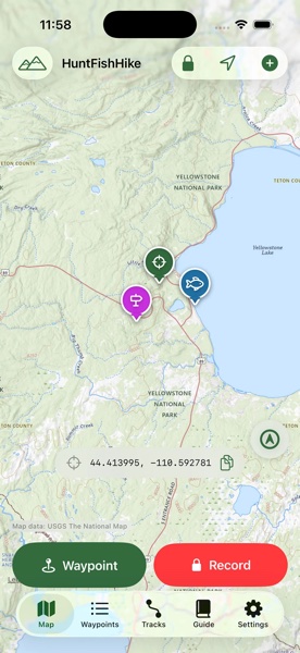
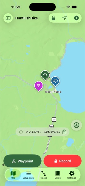
Real topo maps. Even with zero bars.
Switch between standard, satellite, hybrid, and USGS topographic map styles right on the map screen. Before you lose signal, download your hunting unit, trailhead, or lake for fully offline use — no connection required once you're out there.
- Standard, satellite, hybrid & topo map styles
- Offline map downloads for any area you frame
- Live coordinate readout in decimal, DMS, or DMM
- "Offline / saved map" status chip so you always know your coverage
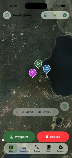
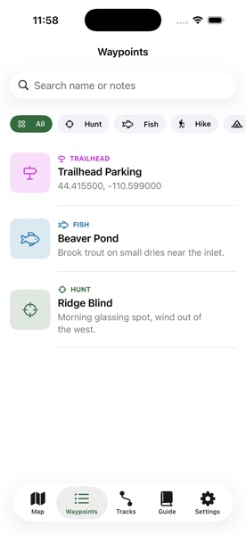
Every honey hole, trailhead, and stand — pinned.
Drop a waypoint in one tap and tag it by category: hunting, fishing, hiking, camp, trailhead, vehicle, water, or other. Add a photo, notes, and get directions back with one tap — in Apple Maps, Google Maps, or Waze.
- 8 color-coded categories built for the outdoors
- Photos, notes, and searchable waypoint list
- One-tap directions and ShareLink to send a spot to a buddy
- Filter and search your whole season of spots at a glance
Record the route. Relive the hunt.
Hit record and HikeHuntFish lays down a live GPS track with distance, time, elevation, and pace — pause, resume, or drop a waypoint mid-hike without losing your line. Every track gets a shareable map card and an on-device AI recap of your trip.
- Live distance / time / pace stats while you move
- Pause, resume, and mid-track waypoint drops
- Export to GPX for any other mapping tool
- Shareable track card with route, stats, and summary
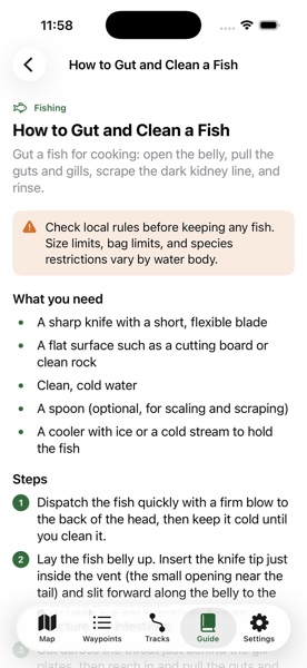
42+ guides for the moment you need them most.
No signal, no problem. HikeHuntFish ships with a full offline field guide — fishing, hunting, fire & shelter, water, navigation, first aid, wildlife, and camp skills — plus an on-device AI assistant that answers your question from the guide, right in your pocket.
- Fishing, hunting, first aid, fire, water & navigation guides
- Ask the Field Guide — on-device AI, grounded in real articles
- Urgent-term banner points straight to 911 / Emergency SOS
- Works fully offline, anywhere you are
Built for the backcountry, not the boardroom.
Back to Truck
Mark your vehicle or camp and get a live compass bearing and distance back — no more wandering ridgelines after dark.
Legal Light & Moon Phase
On-device sunrise, sunset, legal shooting light, and moon phase so you know exactly when you can hunt.
Tree Season Mode
A built-in Christmas tree season guide every November and December — because HikeHuntFish is for every trip to the woods.
One app. Every tab you actually need.
Built specifically for hunters, anglers & hikers — not just one.
Most land and mapping apps pick a lane: hunting or hiking or fishing. HikeHuntFish covers all three in a single, focused app without the clutter of parcel-data subscriptions you'll never use.
| Feature | HikeHuntFish | Typical single-purpose app |
|---|---|---|
| Hunting, fishing & hiking waypoints | ✓ Built in | Often one category only |
| Offline topo maps | ✓ Download any area | Varies by app |
| GPS track recording with AI recap | ✓ Included | Usually a separate app |
| Back to Truck compass navigation | ✓ Included | Rare |
| Offline field guide + on-device AI assistant | ✓ 42+ articles | Not included |
| Legal shooting light & moon phase | ✓ On-device | Varies |
| Free to start | ✓ Yes | Varies |
One app for every reason you leave the trailhead.
🎯 Hunters
Mark stands, blinds, and glassing knobs. Check legal shooting light and moon phase before first light. Navigate back to your truck in the dark without a second thought.
🎣 Anglers
Pin every honey hole with notes on what's biting. Record the hike in to a backcountry lake and know exactly how to get back next season.
🥾 Hikers
Drop trailhead and water-source waypoints, track distance and elevation on every hike, and lean on the offline field guide if conditions turn.
Your next trip starts with a pin on the map.
Download HikeHuntFish free and start mapping your hunting, fishing, and hiking spots today.
Common questions
Does HikeHuntFish work offline?
Yes. HikeHuntFish Premium lets you download topographic maps for your hunting, fishing, or hiking area ahead of time, so you still have maps, waypoints, and navigation with zero cell signal.
Is HikeHuntFish free?
Yes. You can drop waypoints, view maps, record a limited number of tracks, and read field guides for free. HikeHuntFish Premium unlocks unlimited waypoints, GPS track recording, offline map downloads, and the full field guide library.
Can HikeHuntFish get me back to my truck or camp?
Yes. The Back to Truck feature drops a pin at your vehicle or camp and gives you a live compass bearing and distance so you can walk straight back, even in the dark or thick timber.
What kind of maps does HikeHuntFish use?
HikeHuntFish supports standard, satellite, hybrid, and USGS topographic map styles, with offline downloads available for areas without cell service.
Does HikeHuntFish work for hunting, fishing, and hiking?
Yes. HikeHuntFish was built for all three. Waypoints have dedicated categories for hunting spots, fishing holes, trailheads, campsites, and more, and the field guide covers hunting, fishing, and hiking know-how.
What devices does HikeHuntFish support?
HikeHuntFish is available for iPhone and iPad on the App Store, running iOS 17 and later.